BVA's Getting Started Guide: Start Flying! >> Which Controller do I Contact?
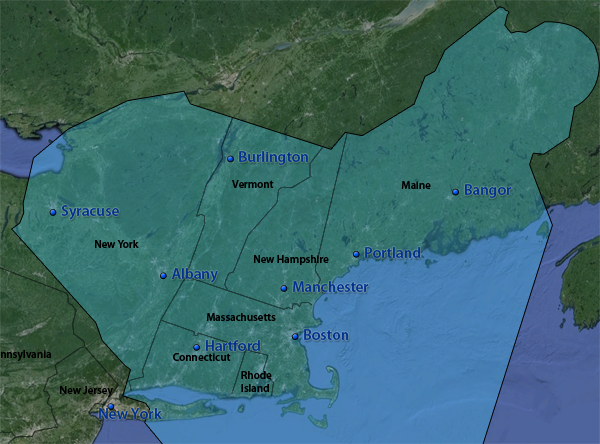
Controllers at Boston Virtual ARTCC provide ATC within the Boston ARTCC (ZBW). The airspace covers 165,000 square miles of airspace in Connecticut, Vermont, Massachusetts, Rhode Island, Maine, New Hampshire, and parts of New York State:
The position the controller is working is identified by the following abbreviations:
Certified controllers always log in to the highest position they wish to control and cover all positions "underneath" that aren’t already staffed. For example, if you see a Boston Approach controller online (e.g., BOS_APP on 133.00), the controller handles approach, and will also cover Boston Tower, Ground, and Clearance, if another controller is not logged on to any of those positions.
This controller further controls any towered (class B, C, or D) airport within their underlying airspace. The same BOS_APP controller will provide tower services (clearance, taxi, takeoff, etc.) at KBVY, KLWM, KOWD, and KBED, which are all located within the lateral boundaries of BOS_APP. Thus, a departure from KLWM would also contact BOS_APP for clearance, taxi, and takeoff when LWM_TWR is offline.
One way to determine which "Approach" or "Center" airspace the airport is located in is to look at the airport's communication information by searching for the airport code on AirNav:
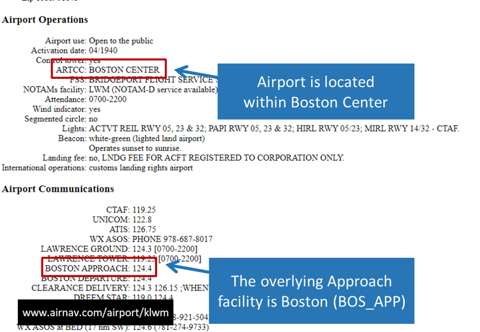
In the above image, the airport is located within Boston Center (which would connect to the network as BOS_CTR) and covered by Boston Approach (which would be connected to the network as BOS_APP). If you are ever unsure of which controller to contact, call the controller you think will provide coverage via voice, provide your location, and ask for the correct frequency. The controller will be happy to point you to the right place. Because ATC audio is range-based, if you don't get a response from one controller, you may have to try contacting someone else.
At all times, when there are no controllers online, monitor UNICOM on 122.80, and treat the network as you would for a VFR flight in uncontrolled airspace, making appropriate position reports via text or voice and keeping an eye out for other traffic.
If a controller is logged in as Tower or Ground with no Approach or Center frequency active, that controller will not handle the duties of Approach (i.e., that controller will not provide radar vectors to IFR airrcraft). In this scenario, inbound IFR aircraft should monitor UNICOM on 122.80 until they turn final, and then contact Tower for a landing clearance. Likewise, the departure frequency for all departing aircraft in this situation is also UNICOM. If you’re not flying in an active controller’s airspace, monitor UNICOM to communicate with other pilots and announce intentions.
For example, consider the following list of active controllers:
In such a scenario:
Active controllers will appear in your pilot client and also on network monitoring tools like Vattastic and VATSpy. Please remember that when you leave our ZBW home airspace, you are no longer flying with BVA controllers. While members are encouraged to explore the world of VATSIM, it's important to remember that you are only talking to BVA controllers when you are flying within the Boston (ZBW) ARTCC.
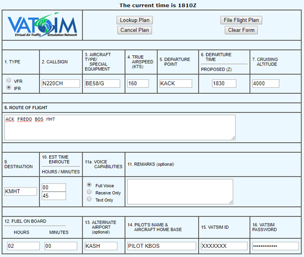
If you are flying IFR, a flight plan is required. Flight plans are also recommended for VFR operations. While XSquawkbox does have the functionality to file flight plans, flight plans filed in this manner do not always transmit correctly to controllers. X-Plane pilots are urged to file flight plans using VATSIM's Flightplan Prefile. You can complete the form before or after connecting to the network. Complete the form by entering the following information:
| Block | Details |
| 1. Type | The type of flight plan being filed. Available options are:
|
| 2. Callsign | This must match the callsign selected when connecting to the network. |
| 3. Aircraft Type / Special Equipment | The aircraft type should match what is entered into XSquawkbox. Enter an appropriate Type Abbreviation. Follow the type with the Equipment Suffix for your navigation capabilities (use our Equipment Type Suffix Selector if you are unsure of which suffix to choose from). Examples: B736/L, H/A332/L, C172/G, BE58/A. |
| 4. True Airspeed (KTS) | Planned cruise speed of the aircraft, expressed in True Air Speed (TAS) as knots. |
| 5. Departure Point | The departure airport for the flight. |
| 6. Departure Time | The proposed time of departure, in UTC (or "Zulu"); for reference, the current Zulu time appears at the top of the page. |
| 7. Cruising Altitude | The planned altitude for the flight. IFR flights are always flown at altitudes on the thousands.
VFR flights follow the same rules as IFR flights, but add 500' to each altitude. Remember, VFR flight is prohibited in Class A airspace (above 17,999').
|
| 8. Route | Enter the route of flight, including any proposed SIDs or STARs (if operating IFR). VFR routes can be as simple as "Highway 25". If you flying IFR and are unsure of which route to file, BVA maintains a set of Preferred Routes for common citypairs in our airspace. |
| 9. Destination | The planned arrival airport. |
| 10. Time Enroute | Planned duration of the flight, in hours and minutes. |
| 11a. Voice Capabilities | Select "Full Voice". All BVA members are required to use voice to communicate with ATC. |
11. Remarks |
Enter any remarks or additional comments in the flight plan. For example, you may wish to enter "New Member" or "Student Pilot" to let controllers know that you are learning the airspace and procedures. |
| 12. Fuel on Board | The amount of fuel on board the aircraft, expressed in hours and minutes of flying time at cruise power settings. |
| 13. Alternate Airport | The airport you might divert to in the event bad weather is encountered at the destination (not required for all flights). |
| 14. Pilot's Name and Aircraft Home Base | Your name, and the home base FAA code of the aircraft. |
| 15. VATSIM ID | Your VATSIM ID (the same thing used to connect to the network). |
| 16. VATSIM Password | The VATSIM password you use to connect to the network. |
Once completed, the flight plan form might look like this, for a simple IFR flight between Nantucket and Manchester:
| It's time to begin your flight! |